Makalu Base Camp Trek

Makalu Base Camp Trek

Duration 20 Days
We offer special group discounts, please contact us for the offers.
Trip Duration 20 Days
Group Size 2-16 People
Maximum Altitude 4,500 m
Difficulty Grade Challenging
Start & End Point Kathmandu-Kathmandu
Best Seasons March, April, May, Sept, Oct, Nov

Trip Highlights of Makalu Base Camp Trek

  • See Everest from a unique angle, its eastern Kangshung face.
  • Gain view of eastern Nepal, as far away as Kangchenjunga.
  • Pass from green terraced farmland to glaciers and waterfall
  • Spot some of the rarest wildlife in Nepal, including the Red Panda

Overview of Makalu Base Camp Trek

The Makalu Base Camp trek is an off-the-beaten-path expedition in the Himalayas of Nepal. It’s longer, more rugged, and presents an intense physical challenge compared to more established trekking routes in Nepal. For experienced trekkers who relish a challenge, this is a great trek with ample rewards. This remote trail encompasses some of the best that Nepal has to offer-quiet trails, vibrant terraced farmland, rural cultures, rhododendron forests, rare wildlife and several 8,000 meter-plus peaks.

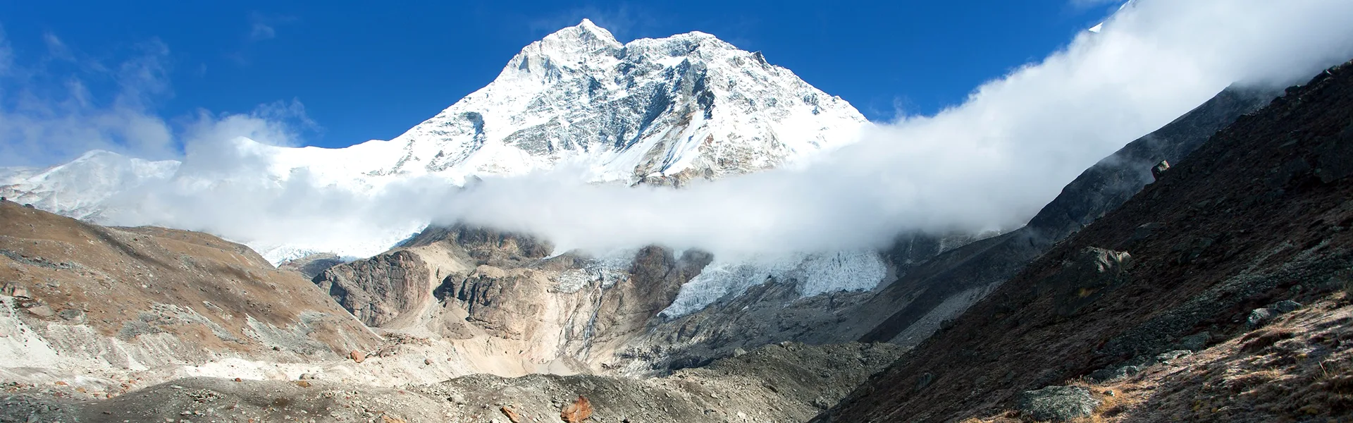
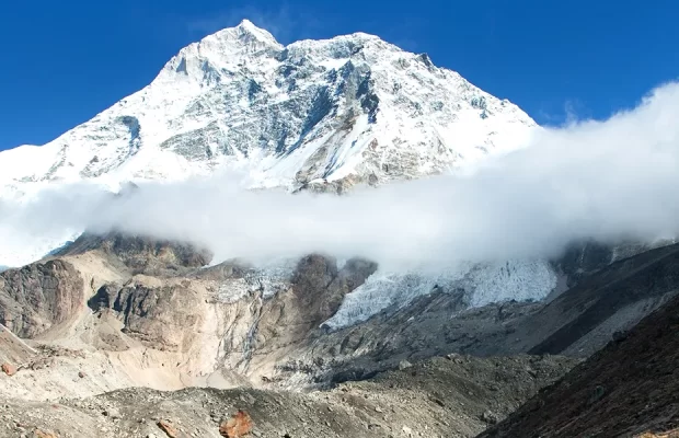
Makalu is the fifth highest mountain in the world (8,481m), yet the trek to its base camp is a less frequented route due to its relative inaccessibility. However, it’s not too hard to reach, as there are daily flights to Tumlingtar (which is a few hours’ drive from the trailhead) and basic lodges along the way.

The Makalu Base Camp trek is an ideal trek for nature-loving trekkers who want to experience a variety of landscapes and cultures, as well as uncommon views of some of the world’s tallest mountains, including Everest.

The trek starts in warm, terraced farmland inhabited by the Rai people, an ethnic group found predominantly in the hills of eastern Nepal. As the route ascends, you will pass through rhododendron forests (most impressive in the spring, when the flowers bloom. Amazing red, purple, pink and white and forests which is some of the last areas of pristine forests and alpine meadows in Nepal.

Deeper into the mountains, past the Barun River Valley, you will pass steep granite cliffs, glaciers, and spectacular waterfalls. At the higher elevations live the Sherpa people, an ethnically Tibetan group who predominantly reside near Everest.

From Makalu Base Camp there are spectacular views of the rarely seen Kangshung face of Everest, as well as Lhotse, Chamlang, and Kanchenjunga in the Far East. The Makalu Barun National Park is the eighth largest in Nepal, covering 2,330 sq.km, and is home to some of the rarest flora and fauna in Nepal.
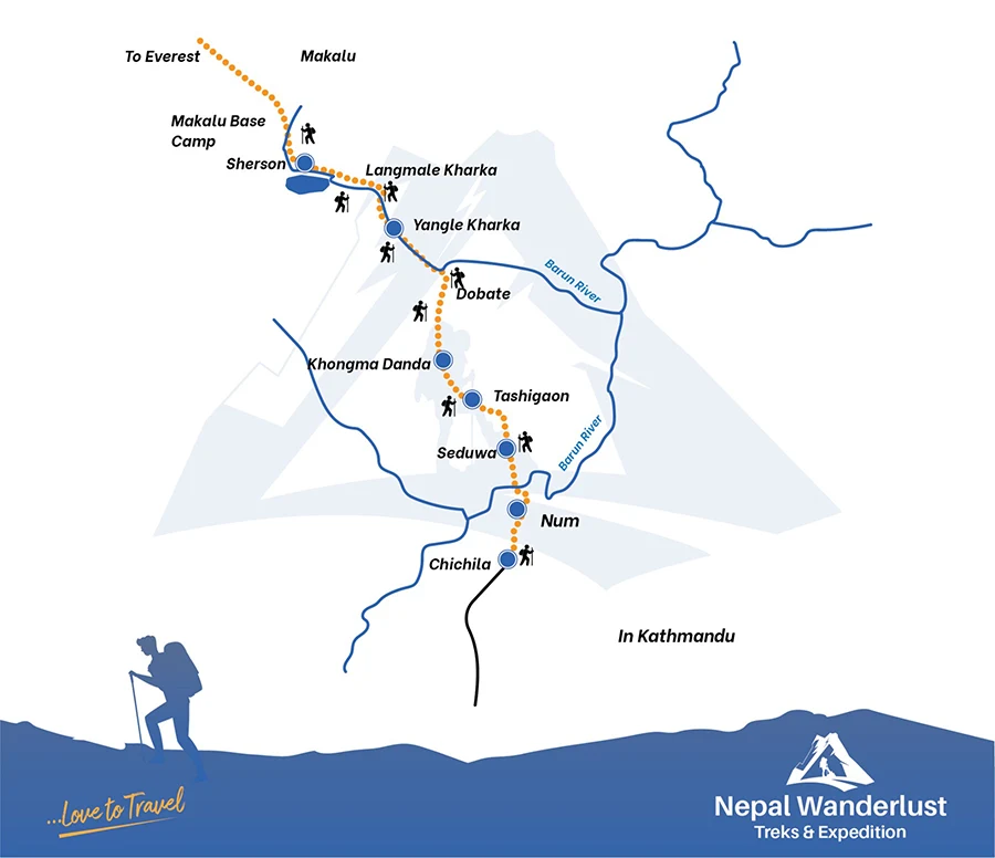
Brief Itinerary

Day1: Arrival at Kathmandu

Day2: Kathmandu Sightseeing and Trek Preparation

Day3: Fly toTumlingtar and drive to Num

Day4: Trek to Seduwa

Day5: Tashigaon

Day6: Trek to Kongma Danda

Day7: Acclimatization walk to Khongma La

Day8: Trek to Dobato

Day9: Trek to Yangle Kharka

Day10: Trek to Langmale Kharka

Day11: Trek to Makalu Base Camp

Day12: Makalu Base Camp Exploration

Day13: Trek to Yangle Kharka

Day14: Trek to Dobato

Day15: Trek to Khongma

Day16: Trek to Tashigaon

Day17: Trek to Seduwa

Day18: Trek to Num and drive to Khandbari

Day19: Drive to Tumlingtar. Fly to Kathmandu

Day20: Depart from Kathmandu

Makalu Base Camp Trek Route Map

Makalu Base Camp Trek Route Map

Itinerary of Makalu Base Camp Trek

01
Day 01: Arrival at Kathmandu

By the time you’ve arrived at the Tribhuvan International Airport, our representative will meet you at the airport and lead you to your hotel, where you may unwind for a while before continuing with you journey. In the meanwhile, our office representative will walk you through all of your activities on the itinerary.

Meals: Included

Elevation: 1350m

02
Day 02: Kathmandu Sightseeing and Trek Preparation

Kathmandu has a special atmosphere during the early morning hours when the city is slowly coming to life yet not too chaotic. It’s great time to walk and explore the streets or have a tea overlooking one of the local courtyards or durbar squares. There are a number of ways you can spend the day given the many incredible sights around the Kathmandu Valley. Later in the evening, head out for dinner at one of the city’s great eateries.

03
Day 03: Fly to Tumlingtar. Drive to Num 3-4 hours

You will be received from your hotel for airport towards flight to Tumlingtar. The flight usually takes around 35 minute and the views of the mountains are great if there are no clouds. From airport you will drive for about an hour in a winding road uphill to Khandbari, a major town in the district which houses the government officials. There is plenty of rural life to observe as you head upwards with fields of corn, bamboo and sal trees. You continue on a winding, dirt road to the highest point at 1,960m before descending to Chicula 1,900m, a small town with a police checkpoint where you have to present your trekking permit. There are pleasant views of the surrounding forested hillsides. The road deteriorates a bit from Chicula so it’s a bumpy ride from here most of the way till Num. Don’t be surprised if your vehicle gets temporarily stuck, either behind grounded truck, or just stuck on the rocky, muddy toad. Locals usually be relied upon to help get you out of a tight spot!

Flight: 35 min

Drive: 3-4 hours

Max elevation: 1,960m

Overnight: Teahouse

04
Day 04: Trek from Num to Seduwa

Today you have a steep decent to Arun River, which takes around 2 hours, and a big climb to Seduwa, losing and regaining your height in one day. The walk down to the river is through cardamom crops (the largest cash crop in the area), and the path is on big stone steps all the way to the river at 770m. It’s very hot, but the scenery in rural Nepal is at its best. You cross the suspension bridge over the Arun River and begin the long, winding climb to Seduwa, passing groves of giant bamboo, village life. There is a school in Seduwa, as well as many houses and small shops, and a few tea houses and small shops, and a few tea house scattered across the hillside.

Trekking Distance: 8 km

Trekking Time: 5-6 hours

Max elevation: 1560m

05
Day 05: Trek from Seduwa to Tashigaon

It’s an easy walk today unlike brutal ascents of yesterday. You begin climbing on a path with many stone steps and pass several mani walls as tou head into Sherpa country. You walk through many small farms dotted across the hillside, cardamom plantations and bamboo and rhododendron forests. It’s certainly a varied, undulating walk today. After approximately two hours you reach the small settlement of Chyaksa Danda at 1,900m. There’s a tea shop, a school and several houses here. You may here barbets, cuckoos and laughing thrushes calling through the trees. In some places you are walking through dense forest and have to cross a few streams on good log bridges. You can see you destination, Tashigaon, on the hillside ahead, although it takes longer than you might think to arrive, as you contour on an undulating path. Eventually you descend to a log bridge just before your final push on steps to reach Tashigaon. The lodges are all perched on the top so you have a bit of climbing through the village to earn you Dal/Bhat.

Trekking distance: 7.2 km

Trekking time: 7 hours

Max elevation: 2,100m

06
Day 06: Trek to Khongma Danda

Be prepared for a lot of ascent today! You begin by ascending through stone steps. After a while you cross a log bridge and continue ascending through stunning rhododendron forest. It’s steep climb but a lovely walk with tree-pies, verditer flycatcher and warblers tweeting through the trees, with sparrow-hawks overhead. In April the rhododendron and magnolia trees in bloom provide a colorful foreground with snow-capped summits to the east. As you look back you’ll see Tashigaon way beneath you.

After approximately three hours you reach Dhara at 2,867m which has a tea shop, and you are likely to have your lunch here aa it’s your last place to have refreshment atop until you reach Khongma. Leaving Dhara it’s a cliff of around one hour to Unshisa at 3,200m, where you pass a giant rock. There’s a tea hut and prayer flags marking this pass. From Unshisa it’s more relentless climbing on stone steps through rhododendron forest. Eventually after 2-3 hours toiling upwards from Unshisha brings you to Khongma Danda at 3,560m. There are three lodges at Khongma, and there may be quite a bit of snow here as well.

Trekking distance: 7.2km

Trekking time: 7 hours

Accommodation: Teahouse

07
Day 07: Acclimatisation walk to Khongma La

It’s essential to acclimatize properly, so we strongly recommend that you walk up to the Khongma La today. You leave your tea house and begin ascending on stone steps all the way up to the pass at 3,890m through rhododendron bushes. It should take you an hour or so to reach the pass. You can go a little beyond if you are keen-your guide will advise. You then retrace your steps back to Khongma., fit and acclimatized ready to tackle the four passes tomorrow, the first one of course being the Khongma La.

08
Day 08: Trek to Dobate

Today is truly spectacular, crossing four high passes with airy traverses and dramatic ridge sections offering near-constant stunning views of snow-capped peaks. Be prepared for snow though if you are trekking in April. There is one lonely tea shop on the Shipton La, but likely you won’t have lunch until you teach Dobate so make you take plenty of snacks and water with you as it’s a long , tough day ( you may be given a packed lunch today). It takes around one hour of ascent through rhododendron bushes until you reach your first pass of the day-the Kongma La at 3,890m. From there, if it’s clear, you’ll see Makalu and Chamlang. You descend for a short while before ascending towards your second pass. There are views of Kangchenjunga to se as you traverse an airy ridge. Some steep atone steps bring you to Sano Pokhari Danda at 4,105 with Sano Pokhari Lake below. To reach here from Khongma La will take around an hour, although it might take longer if have to go through snow. More undulations bring you to the highest pass-the Shipton La at 4,200m. There is a tin shelter/tea shop here which serves trekkers and pilgrims during the season. The pass is marked by a mani wall adorned with prayer flags near the shelter. It’s quite a steep pull up to the Shipton La but not difficult.

You descend on less steep ground to Kalo Pokhari Lake 4,080m. It’s adorned with prayer flags and us visited by Hindu pilgrims during the Janai Purnima festival. From the lake, it’s an easier climb to your last pass of the day-the Keke La at 4,170m. Finally, a further 45 minutes or so of descent brings you to your lodge at Dobate-a very welcome sight after your four pass toils! There is a pretty good l, clean lodge here with a friendly and welcoming owner. The dal bhat will taste especially on this tiring day.

Trekking distance: 7.6km

Trekking time: 6-8hours

Max elevation: 4,200m

Accommodation: Teahouse

09
Day 09: Trek to Yangle Kharka

You will have a really pleasantly decent through rhododendron and pine forests this morning. Look out for Guldenstadts, redstarts, minivets, tragopans and magpies in the trees. There is a steep descent towards the Barun River through the forest and this can be tricky with lingering snow. Eventually you teach the river and then begin your walk on a path underneath a substantial landslide area. You watch glimpses of Chanlang and Tutse en route this morning.

After a brief ascent you reach the tea shop at Themanthang Kharka, 3,500m. It takes around four hours to reach this spot from Dobate. There is an impressive waterfall just before you reach Themanthang. From here you walk for a short while until crossing the Barun Khola on a wooden bridge. The trail undulates, and you have the river now on your left. Quite a bit of work has been done to construct a story path in places approaching Yangle Kharka. It takes about 1.5hours from the tea shop at Themanthang to reach the meadows of Yangle Kharka and your lodge for the night. It’s a wild, remote and windy spot.

There is a monastery (which is closed) just down from the lodge, providing an attractive foreground for photos with the snowy mountains behind.

Trekking distance: 9.7km

Trekking time: 5-6 hours

Elevation: 3,630m

Accommodation: Teahouse

10
Day 10: Trek from Yangle Kharka to Langmale

You descend from your stay to the river and small monastery. It’s a pleasant, flattish start keeping the river on your left, with the arresting scent of juniper as you walk. You pass many colourful prayer flags lining the trail. The dramatic cliffs soar either side of you, and the views ahead are dominated by Peak 4, Peak 6, Peak 7 and Yaupa. It really is a fabulous day, with jagged snow-clad summits, vertical cliffs, waterfalls, and sacred caves as visual feast.

The trail opens out as you walk past the pastures of Jhak Kharka. Yak Kharka and eventually Merek where a welcome tea shop appears after about 2.5 hours of walking. Take it slow and steady here as you will no doubt be feeling the altitude as you toil upwards, heading towards Langmale. It takes around 2 hours to reach your tea house at Langmale from Merek. The views here are sublime, with Peak 7 providing a breathtaking backdrop from the lodge rooms. A mani wall adorned by prayer flags sits just in front of the row of rooms. Black redstarts and Choughs are quite common here.

Trekking distance: 10.5 km

Trekking time: 5 hours

Max Elevation: 4,420 m

Accommodation: Teahouse

11
Day11: Trek to Makalu Base Camp

A truly sublime day on the trail today. Peak 7 is almost a constant companion on a good path-the going feels tough at this altitude so take it bery easy. You’ll have another dramatic aspect to marvel at. In parts you’ll be hopping from boulder to boulder, but mostly you’re on a reasonable, sandy trail. Obviously you are gaining 400m of height to you destination, but the trail undulates gently and there are only a few steeper sections to get you puffing.

Peak 4 comes into view as you progress. After a couple of hours walking, you reach a wide, flat area with a locked small stone hut-this is called Shershong, 4,630m, making a good camping area. Eventually Makalu comes tantalizing into view. Its formidable face with its icefalls, crevasses, jagged edges makes you gaze up in awe. As you round a few bends, you wonder when the base camp will reveal itself. Eventually you will see the lodges and (if in spring) a huddle of tents which mark the base camp. You descend, cross the river, and in five minutes you arrive at your long-awaited destination. As you would expect, the world’s fifth highest mountain, Makalu, completely dominates the view. Many Tibetan snowcocks, hill pigeons, black redstarts and mountain finches may be seen around the base camp.

Trekking Distance: 8.7km

Trekking time: 5-6 hours

Max Elevation: 4,800m

Accommodation: Teahouse

12
Day12: Exploration day at Makalu Base Camp

One option today which assures the most glorious panoramic views is to climb to the ridge-around 5,300m- above the base camp. You cross the river on the log bridge and ascend on a vague, slightly indeterminate path for around 3 hours. From this viewpoint you can see Everest, Lhotse and Nuptse as well as close-up, dramatic views of Makalu, Peak7, Peak 6, and Peak 4. Retrace your steps to the base camp, total time it will take is 4-5 hours. It’s a strenuous undertaking as it’s steep altitude will surely takes you above 5,000m.

There are some softer options, which include following a path to view the lake beyond base camp. There is also much shorter ridge climb you can do just above base camp, and there’s a small hill at the head of base camp marked with prayer flags which is around an hour’s walk, out and back. Your guide may also have other suggestions.

13
Day13: Return to Yangle Kharka

It’s with heavy heart that you leave behind the overwhelming spectacle that is of Mount Makalu, and begin retracing your steps to Yangle Kharka. It takes around 1.5 hours to reach the meadow of Shershong, marked with a hut with bright orange tarpaulin. A further hour or so brings you back to Langmale, where you may have tea and possibly lunch. About 1-2 hours of walking downhill brings you next to the tea shop at Merek. It’s good to chill here with a cup of tea before weaving your way through pine forests back to Yangle Kharka. It takes approximately 2-3 hours to reach here from the tea shop at Merek. A welcome hot shower awaits if you pay 200 ruppes!

Trekking distance: 16km

Trekking time: 6-7 hours

14
Day14: Return to Dobate

It’s a really pleasant gentle meander following the river down to the tea shop at Themanthang , passing many rhododendron bushes as you approach. There’s a wooden bridge adorned by prayer flags to cross just before Themanthang. It’ll take around 1.5 hours to reach here.

After a short walk you will have to negotiate the landslide area, which takes around 1.5hours. Take care on this as there are some narrow sections to pass. After an undulating stretch, you start climbing steeply through the rhododendron forests. If you’re lucky you may see a Himalayan Monal here- Nepal’s national bird, resplendent in its rainbow colors. The going eventually eases and the ascent becomes more gradual as you approach the hut at Dobate. Take note that after the tea shop at Themanthang, which comes early in your walk, there are no other refreshment stops until you reach Dobate, so make sure you take snacks.

Trekking Distance: 9.3km

Trekking time: 6 hours

15
Day15: Return to Khongma

Today is your last chance to get captivating views of the high mountains, including Kangchenjunga. You begin ascending to the Keke La at 4,200m. Enjoy your stop here at the tea house. Another hour or so of walking downhill round the mountains will bring you to Sano Pokhari Danda at 4,105m. A further hour of undulations brings you back to the final pass-the KhongmaLa at 3,890m, marked by a mani wall. Approximately 250m of descent, mainly on stone steps, brings you back to your lodge at Khongma. Look out for blood pheasant which can occasionally be seen wandering in the snow between the rhododendron bushes.

Trekking distance: 7.6km

Trekking time: 6-7hours

16
Day16: Return To Tashigaon

You descend from Khongma down to Dhara Kharka which takes around 2 hours. You’ll no doubt stop for a cup of tea here. After that descend to Tashigaon then takes further 3 hours.

Trekking distance: 6.4km

Trekking time: 5 hours

17
Day17: Return to Seduwa

Retracing your steps back to Seduwa today will take around 4-5 hours.

18
Day18: Trek to Num. Drive to Khandbari

It’s a long, fairly steep climb, mainly on stone steps, all the way down to the Arun River at 770m. It will be feeling very warm now as you head deep into the forest lower down. You cross the river and endure the 800m climb all the way back to Num. Now you can congratulate yourself on the successful completion of a challenging and rewarding trek!

Finally, you return by vehicle to Khandbari where you spend your last night in the mountains.

Trekking distance: 8 km

Includes/Excludes

We are updating the contents.

Essential Information - Makalu Base Camp Trek

We are updating the contents.

Reviews on Makalu Base Camp Trek

Be first to post a review in this trip.